Lindsey has been described as a forgotten Anglo Saxon Kingdom. Proofs that it existed:
- Genealogy of its kings preserved in an 8th Century collection
- Bede refers to it as a Provincia, the term he uses for Anglo-Saxon kingdoms
- Up to the 9th century it had its own bishop, indicative of being a former kingdom
- The 7th century Tribal Hidage listing 35 tribes, rates it at 7000 hides, the same as the kingdoms of the South and East Saxons.
Lindsey is unusual as an Anglo Saxon kingdom in preserving links with the preceding British territory, Lindes, in its name and in a Celtic personal name within its genealogy of kings suggesting Anglo-Saxon/ British intermarriage. The Anglo-Saxon name for the kingdom derives from Lindisfaran, the people who migrated (faran) to the land of the people of Lindes.
The name derives from the city of Lindum Colonia, hence Lincoln, hence Lindes. the British people of the area dependent on the city, which was the seat of a late Roman bishopric and one of four provincial capitals of late Roman Britain. Eight lead fonts marked with chi-rho insignia were found within the envisaged Roman episcopal see based on Lindum Colonia. Out of 28 found in Britain, the great majority are within its Province of Britannia Secunda. The area was prosperous in the 4th century, followed in the 5th by a cessation of urbanism and monetary use, but this didn’t necessarily mean a decline in population, rather a shift from producing a circulated surplus and funds for the Empire to greater pastoralism with little evidence of reforestation.
The place name Tealby in the Wolds appears strangely to come from a tribal name from North Italy/ Southern France, the Taifali. The late Roman Notitia Dignatatum refers to Equites Taifali under the Comes Britannarium, part of the mobile field army. Archaeology shows a circle of 4th century gold coins possibly implying a defensive ring about Lincoln in the final Roman British period. There are also finds of late Roman spurs with most found near Tealby! Possibly part of the field army stayed on, their descendants gradually changing from being soldiers to warriors. Their continued presence may explain why Britons may have been more successful here at controlling immigrant groups than elsewhere in eastern Britain.
It is unclear if the continuance of British power based on Lincoln was not just in Lindes, but throughout the former Roman province. Green suggests Lindes succeeded to the Iron Age Corieltavi tribe, fitting the pattern suggested by Laycock of pre-Roman tribal groups reviving with Roman withdrawal.
There is significant archaeological evidence for continuance of a British kingdom:
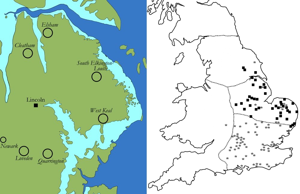
- Anglo Saxon cremation cemeteries form a circle around Lincoln, the closest 27 km away.
The cremation centres were central places for a rural population without urban centres. Their locations match Dark Age defensive sites. The pattern is unique in indicating continuing British control over where Anglo-Saxon settlement occurred, confirming the Gildas pattern of Anglo-Saxons employed by the British for defence etc, who later rebelled, in Lindes until in the mid-6th century the Anglo-Saxons took over. Does it indicate continuing British power where there are other “gaps” in early Anglo-Saxon cemeteries with late Roman centres surviving and exercising control over Anglo Saxon settlement? Green suggests large cremation cemeteries were succeeded as central places by the meeting places of later Wapentakes.
- Unusual concentrations of British hanging bowls and penannular brooches, wearing which indicated Britishness. However some were found in cremation cemeteries suggesting eventual acculturation.
- Then there are zoomorphic buckles and belt fittings associated with local British militias worn by individuals who wished to emulate military dress.
- Two successive churches were sited at Lincoln within the former forum, one late Roman, the other apsidal and larger, 5th century.
Four battles in the country of Linden are cited in the 9th century Welsh Historia Brittonum. It refers to a British victory at Mount Bardon in c500, also referred to by the 6th century author, Gildas. The Historia refers to the probably unhistorical Arthur by historicisation, a process of using fiction to imagine (and create) the past. Gildas refers to Ambrosius Aurelianus, the “last Roman”. Some have suggested Bardon was near Bath. Green suggests a place and place name in Lincolnshire and that this would make sense with survival of British power here. Green suggests Historia Brittonum reflects a Welsh memory of the kingdom of Lindes.
She also cites Y Gododdin, 7th century British heroic death songs, which record the defeat of a Gododdin war band, from what is now south Scotland, at Catraeth ( probably Catterick in north Yorkshire) in fighting another British kingdom and its allies. Difficult language in Old Welsh can be interpreted that this included kingdom-less men from Lindes.
Green believes Lindes continued into the mid 6th century and was taken over by the Anglo-Saxons, by a process involving acculturation. This is supported in place names eg Washingborough, the fortified place of the Wassinga, the people/ dependents (OE) of Wassa. However this is a British Celtic derived personal name. Similarly Torksey on the Trent seems to combine the OE suffix ige, island, with an old Welsh personal name, Turc.
By this time, smaller inhumation cemeteries appeared closer to Lincoln. However they were not on the scale of the earlier cremation cemeteries or other inhumation cemeteries of the same period and there were none in Lincoln or in its immediate hinterland.
Springs, supposedly dedicated to St Helena, the mother of Constantine, were more common in Britain than anywhere else in the Roman world. Green thinks they derive from the Christianisation of pagan springs dedicated to the Goddess Alauna and that they mark continued rural British Christianity during the Anglo-Saxon pagan period.
A difficulty is the general archaeological invisibility of British/Welsh continuity. Social and cultural Anglo-Saxon superiority led to the replacement of Brithonic. Place names involving Walh (there are three Lincolnshire Waltons) and Cumbre (eg Cumberworth) appear to be 8th century coinages when Welsh speakers were rare enough for their continuance to be reflected in place names. Presumably before that the presence of Welsh speakers was sufficiently common not to be reflected in place names.
Lincolnshire is split into three parts, Lindsey, Kesteven and Holland, so both the name of the county and of the part of Lindsey are derived from the Roman city name. Lincoln stands on the river Witham which from the late Anglo-Saxon period formed the boundary between the parts of Lindsey and Kesteven. Green argues it wasn’t always so, and that British Lindes and early Anglo-Saxon Lindsey were larger, which makes sense if they were centred on Lincoln and the Witham, rather than being a barrier, provided territorial unity, as it did by being crossed by ten prehistoric causeways dating back to prehistory, which were used in votive disposition from pre-Roman through to the medieval period.
The Tribal Hidage refers to Lindsey as including Hatfield (= heathland), west of the Trent. Later only the Isle of Axholm west of the Trent was in Lincolnshire.
Overall it looks likely that Lindsey originally included what was later north Kesteven, which interestingly combines Ked (Welsh wood ) and Stefna (Norse meeting place) indicating the name may have dated to the Danelaw.
It was thought the Anglo-Saxons destroyed most British territories and lived in small population groups, like those found in Middle Anglia, recorded in the Tribal Hidage. Bede however distinguishes between such Regiones and kingdoms, Principia. Does the Hidage rather represent a detailed document for Middle Anglia to which hide figures for other kingdoms were then added? Instead of disintegrating, Green thinks Roman territories, continued in some form so that Roman civitates became later kingdoms, eg East Anglia/the Iceni, Essex/ the Trinovantes etc . Initially the Anglo-Saxon model followed that of the continent with no kings, but semi-autonomous districts controlled by local leaders which might unite in times of war.
Green goes on to use place name evidence to explain Anglo-Saxon expansion from their original area of settlement, specifically into Northumbria and Mercia.
Lindsey was fought over between the two kingdoms, eventually being absorbed into Mercia in the late 7th century under Basset’s “knock out cup” model of competition. Bede mentions Lindsey under Northumbrian overlordship, with a mass baptism on the Trent and a new stone church at Lincoln c627 before that at York. Green thinks that the two kingdoms fought repeatedly over Lindsey, recognising its mythic importance. She mentions Garwick as a potential wick where this an unusual concentration of coins and amber and ivory in the nearby Sleaford cemetery. She suggests that it was following the battle of the Trent in 679 that this part of Lindsey became part of Kesteven, prompted by Mercian loss of Ludenenwic, and that the Mercians took over of the regione of the Billingas, split between a royal monastic estate focused on Stow Green and a multiple estate based around Sleaford.
